Previous Next
Indian Geography (Part-12)
Some of the major categories under which the river systems of India are grouped are as follows:
1. Himalayan Rivers
2. Peninsular Rivers

1. Himalayan Rivers:
These rivers are again subdivided into two groups. Trans Himalayan and Himalayan. The Trans-Himalayan Rivers originate beyond the Great Himalayas. These are the Indus, the Sutlej and the Brahmaputra rivers. Himalayan rivers are those which originate in the Himalayas and flow through the Northern Plains, e.g., the Ganga, the Yamuna and their tributaries. These rivers are useful for irrigation and navigation and the lowlands drained by them have fertile alluvial deposits.
The Indus System:
Situated to the north of Ladakh range and Kailash Range, it rises near the Mansarover Lake at an altitude of 5,180 metres. It enters the Indian Territory in Jammu and Kashmir where it receives Himalayan tributaries such as the Garstang, Zaskar, Dras, Shyok, Shigar, Nubra, GilgitandHuza.
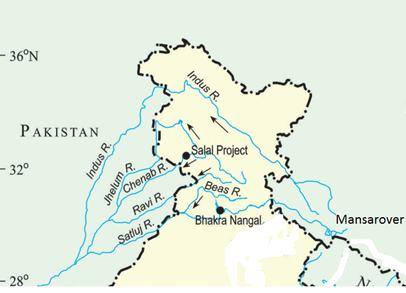
It is well known Punjab tributaries which make the Panjnad are Sutlej, Ravi, Beas, Chenab and Jhelum. Indus with a length of 2,880 km is considered as one of the longest rivers of the world. India can utilise 20 per cent of its discharge under the Indus Water Treaty with Pakistan.
The Brahmaputra System:

The Brahmaputra rises in the glacier about 100 km south-east of Mansarovar Lake. In Tibet, it is known as Tsangpo and runs parallel to the Himalayas. Its two important tributaries Dehang and Luhit meet near Sadiya. Its tributaries are the Subansiri, the Kameng. The Tista, and Manas on the right bank and Burri Dihang, Disang, Kapila and Dhansiri on the left bank. Tista was about 200 years ago a tributary of Ganga but in 1787 the great flood changed its direction and it became a tributary of the Brahmaputra.
The Ganga System:
The Ganga rises in the Up Himalayas (now in the state of Uttaranchal). The river acquires its name after its head-streams – Alaknanda and Bhagirathi unite at Devaprayag. Right bank tributaries of the Ganga in the region of the plain include the Yamuna and the Son besides the minor streams of the Tons and the Purpun.

On its left, the tributaries include Ramganga, Gomati, Ghaghra, Gandak, Kosi and the Mahananda. The total length of the river is 2,525 km and is shared by Uttaranchal and Uttar Pradesh, (1,450), Bihar (445), West Bengal (520). Beyond Falakka, the mainstream of Ganga flows east-south eastwards into Bangladesh and is known as the Padma. Before falling into the Bay of Bengal, the Padma receives the Brahmaputra known here as Jamuna and Meghna.
2. Peninsular Rivers:
The Peninsular Rivers originate in the Western Ghats. They have a large seasonal fluctuation in volume as they are solely fed from rainfall. These rivers flow in valleys with steep gradients. Major rivers of the Peninsula such as Mahanadi, Godavari, Krishna, Cauvery flow eastwards on the plateau and drain into the Bay of Bengal.

The Narmada and Tapti flow eastwards. Narmada rises in Amarkantak plateau and enters Gulf of Cambay. The Tapti rises in Betul district of Madhya Pradesh and reaches the Arabian Sea, west of Surat. The Damodar flows to the north of Ranchi plateau, the Mahanadi originates on the northern edge of Dandakaranya and flowing east reaches the Bay of Bengal. The Godavari rises near Trimbank in Nasik district and drains into the Bay of Bengal.
The Cauvery rises in Brahmagir range on the Western Ghats and finally joins the sea at Devikotta. The Sharavati flows into the Arabian Sea. Dams are built across these rivers and water stored in reservoirs is used for irrigation and generation of electricity.


No comments:
Post a Comment