Showing posts with label geography. Show all posts

Industrial Regions in India

Previous                                                                                        Next

Indian Geography (Part-16)

Industrial Regions in India


Industrial regions emerge when a number of industries locate close to each other and share the benefits of their closeness. They tend to concentrate on certain locations because of the favourable locational factors. Several indices are used to identify the clustering of industries, important among them are:

• The number of industrial units

• Number of industrial workers.

• Quantum of power used for industrial purposes.

• Total industrial output.

• Value added by manufacturing, etc.

Industrial Regions in India

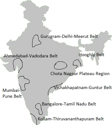
India has several industrial regions like Mumbai- Pune cluster, Bangalore-Tamil Nadu region, Hugli region, Ahmedabad-Baroda region, Chottanagpur industrial belt, Vishakhapatnam-Guntur belt, Gurgaon-Delhi-Meerut region and the Kollam Thiruvanathapuram industrial cluster. The Industrial regions are discussed below:
1. Mumbai-Pune Industrial Region

It extends from Mumbai-Thane to Pune and in adjoining districts of Nashik and Solapur. Besides, industrial development has been rapid in Kolaba, Ahmednagar, Satara, Sangli and Jalgaon districts. Development of this region started with the location of the cotton textile industry in Mumbai. Mumbai, with cotton hinterland and moist climate, favoured the location of the cotton textile industry. Hydro-electricity was developed in the Western Ghats region to meet the requirements of this industry. With the development of the cotton textile industry, the chemical industry also developed. Important industrial centres are Mumbai, Kolaba, Kalyan, Thane, Trombay, Pune, Pimpri, Nashik, Manmad, Solapur, Kolhapur, Ahmednagar, Satara and Sangli.

2. Hugli Industrial Region

It extends from Bansberia in the north to Birlanagar in the south for a distance of about 100 km along the Hugli River. Industries also have developed in Mednipur in the west. Kolkata-Haora from the nucleus of this industrial region. Kolkata emerged as a leading centre of the country. Later, Kolkata was connected with interior parts by railway lines and road routes. Development of tea plantations in Assam and northern hills of West Bengal, the processing of indigo earlier and jute later coupled with the opening of coalfields of the Damodar Valley and iron ore deposits of the Chotanagpur plateau, contributed to the industrial development of the region. Cheap labour available from thickly populated part of Bihar, eastern Uttar Pradesh and Orissa also contributed to its development.

The cotton textile industry also grew along with jute industry, paper, engineering, textile machinery, electrical, chemical, pharmaceuticals, fertiliser and petrochemical industries have also developed within this region. Important industrial centres of this region are Kolkata, Haora, Haldia, Serampur, Rishra, Shibpur, Naihati, Kakinara, Shamnagar, Titagarh, Sodepur, Budge Budge, Birlanagar, Bansberia, Belgurriah, Triveni, Hugli, Belur, etc.

3. Bangalore-Chennai Industrial Region

This region witnessed the most rapid industrial growth in the post-Independence period. Till 1960, industries were confined to Bangalore, Salem and Madurai districts but now they have spread over all the districts of Tamil Nadu except Viluppuram. Since this region is away from the coalfields; its development is dependent on the Pykara hydroelectric plant, which was built in 1932. The cotton textile industry was the first to take roots due to the presence of cotton-growing areas. Along with cotton mills, the loom industry spread very rapidly. Several heavy engineering industries converged at Bangalore. Aircraft (HAL), machine tools, telephone (HTL) and Bharat Electronics are industrial landmarks of this region. Important industries are textiles, rail wagons, diesel engines, radio, light engineering goods, rubber goods, medicines, aluminium, sugar, cement, glass, paper, chemicals, film, cigarette, matchbox, leather goods, etc. Petroleum refinery at Chennai, iron and steel plant at Salem and fertiliser plants are recent developments.

4. Gujarat Industrial Region

The nucleus of this region lies between Ahmedabad and Vadodara but this region extends up to Valsad and Surat in the south and to Jamnagar in the west. Development of this region is also associated with the location of the cotton textile industry since the 1860s. This region became an important textile region with the decline of the cotton textile industry at Mumbai. Located in the cotton-growing area, this region has the double advantage of the proximity of raw materials as well as of the market. The discovery of oil fields led to the establishment of petrochemical industries around Ankleshwar, Vadodara and Jamnagar. The port at Kandla helped in the rapid growth of this region. Petroleum refinery at Koyali provided raw materials to a host of petrochemical industries. The industrial structure is now diversified. Besides, textiles (cotton, silk and synthetic fabrics) and petrochemical industries, other industries are heavy and basic chemicals, motor, tractor, diesel engines, textile machinery, engineering, pharmaceuticals, dyes, pesticides, sugar, dairy products and food processing. Recently, the largest petroleum refinery has been set up at Jamnagar. Important industrial centres of this region are Ahmedabad, Vadodara, Bharuch, Koyali, Anand, Khera, Surendranagar, Rajkot, Surat, Valsad and Jamnagar.

5. Chotanagpur Region

This region extends over Jharkhand, northern Orissa and western West Bengal and is known for the heavy metallurgical industries. This region owes its development to the discovery of coal in the Damodar Valley and metallic and non-metallic minerals in Jharkhand and northern Orissa. The proximity of coal, iron ore and other minerals facilitated the location of heavy industries in this region. Six large integrated iron and steel plants at Jamshedpur, Burnpur- Kulti, Durgapur, Bokaro and Rourkela are located within this region. To meet the power requirement, thermal and hydroelectric plants have been constructed in the Damodar Valley. Densely populated surrounding regions provide cheap labour and Hugli region provides a vast market for its industries. Heavy engineering, machine tools, fertilisers, cement, paper, locomotives and heavy electrical are some of the important industries in this region. Important centres are Ranchi, Dhanbad, Chaibasa, Sindri, Hazaribag, Jamshedpur, Bokaro, Rourkela, Durgapur, Asansol and Dalmianagar.

6. Vishakhapatnam-Guntur Region

This industrial region extends from Vishakhapatnam district to Kurnool and Prakasam districts in the south. Industrial development of this region hinges upon Vishakhapatnam and Machilipatnam ports and developed agriculture and rich reserves of minerals in their hinterlands. Coalfields of the Godavari basin provide energy. The shipbuilding industry was started at Vishakhapatnam in 1941. Petroleum refinery based on imported petroleum facilitated the growth of several petrochemical industries. Sugar, textile, jute, paper, fertiliser, cement, aluminium and light engineering are principal industries of this region. Important industrial centres are Vishakhapatnam, Vijayawada, Vijaynagar, Rajahmundry, Guntur, Eluru and Kurnool

7. Gurgaon-Delhi-Meerut Region

This region is located far away from the mineral and power resources, and therefore, the industries are light and market-oriented. Electronics, light engineering and electrical goods are major industries of this region. Besides, there are cotton, woollen and synthetic fabrics, hosiery, sugar, cement, machine tools, tractor, cycle, agricultural implements, chemical and vanaspati industries which have developed on large scale. The software industry is a recent addition. To the south lies the Agra-Mathura industrial area which specialises in glass and leather goods. Mathura with an oil refinery is a petrochemical complex. Among industrial centres, mention is made of Gurgaon, Delhi, Shahdara, Faridabad, Meerut, Modinagar, Ghaziabad, Ambala, Agra and Mathura.

8. Kollam-Tiruvanantapuram Region

This industrial region is spread over Thiruvananthapuram, Kollam, Alwaye, Ernakulam and Alappuzha districts. Plantation agriculture and hydropower provide an industrial base to this region. Located far away from the mineral belt of the country, agricultural products processing and market-oriented light industries predominate the region. Among them, cotton textile, sugar, rubber, matchbox, glass, chemical fertiliser and fish-based industries are important. Food processing, paper, coconut coir products, aluminium and cement industries are also significant. Important industrial centres are Kollam, Thiruvananthapuram, Alluva, Kocchi, Alappuzha, and Punalur.
Seasons in India

Previous                                                                                        Next

Indian Geography (Part-15)

 Seasons in India


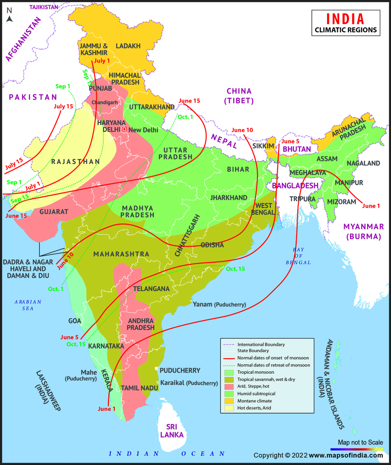
India has a monsoon type of climate. The term “monsoon” is derived from the Arabic word ‘mausim’ which means a seasonal reversal in the wind direction. The season of India influenced by the two types of winds – one blow from the Arabic Sea and second is from the Bay of Bengal. The Indian meteorological department has divided the climate of India into four seasons which are discussed below:


The Winter Season

It begins from mid- November in northern India and stays till February. The temperature decreases from south to the north. The average temperature on the eastern coast is between 24° - 25° Celsius, while in the northern plains, it ranges between 10° - 15° Celsius. Days are warm and nights are cold. Frost is common in the north and the higher slopes of the Himalayas experience snowfall.

During this season, the North-East trade winds prevail over the country. They blow from land to sea and hence, for the most part of the country, it is a dry season. Some amount of rainfall occurs on the Tamil Nadu coast from these winds as; here they blow from sea to land. A feeble high-pressure region develops in the northern part of the country, with light winds moving outwards from this area. Influenced by the relief, these winds blow through the Ganga valley from the west and the northwest. The weather is normally marked by clear sky, low temperatures and low humidity and feeble, variable winds.

A characteristic feature of this season over the northern plains is the inflow of cyclonic disturbances from the west and the northwest. These low-pressure systems originate over the Mediterranean Sea and western Asia and move into India, along with the westerly flow. They cause the much-needed winter rains over the plains and snowfall in the mountains. The peninsular region does not have a well defined cold season. There is hardly any noticeable seasonal change in temperature pattern during winters due to the moderating influence of the sea.


The Summer Season

It begins from March to the middle of June. The whole India experiences increase in temperature because of the summer solstice. During this season, hot violent winds blow during daytime in the north and north-west India which is called ‘loo’. Since the Sun goes gradually towards the north (Summer Solstice), the Inter-Tropical Convergence Zone (ITCZ) begins moving towards the north and passes the 250 latitudes in July.

When the hot and dry land breeze meets the humid sea breezes during this season, violent cyclone originates in that area. This cyclone is known as the pre-monsoon cyclone. This is very violent winds that brought heavy rainfall and hailstorms. This cyclone has a local name which is given below:

• Nor Wester - Eastern India (West Bengal, Bihar, Jharkhand, Odisha). Useful for tea and rice cultivation.

• Kalbaishakhi- West Bengal (In the local language, Nor Wester is called Kalbaishakhi).

• Cherry Blossom – Karnataka and Kerala (Useful for blooming of coffee flowers.)

• Mango Shower – South India (Useful for early ripening of mangoes.)

• Bardoli Chheerha- Assam (In the local language, Nor Wester is called Bordochila)

The Rainy Season

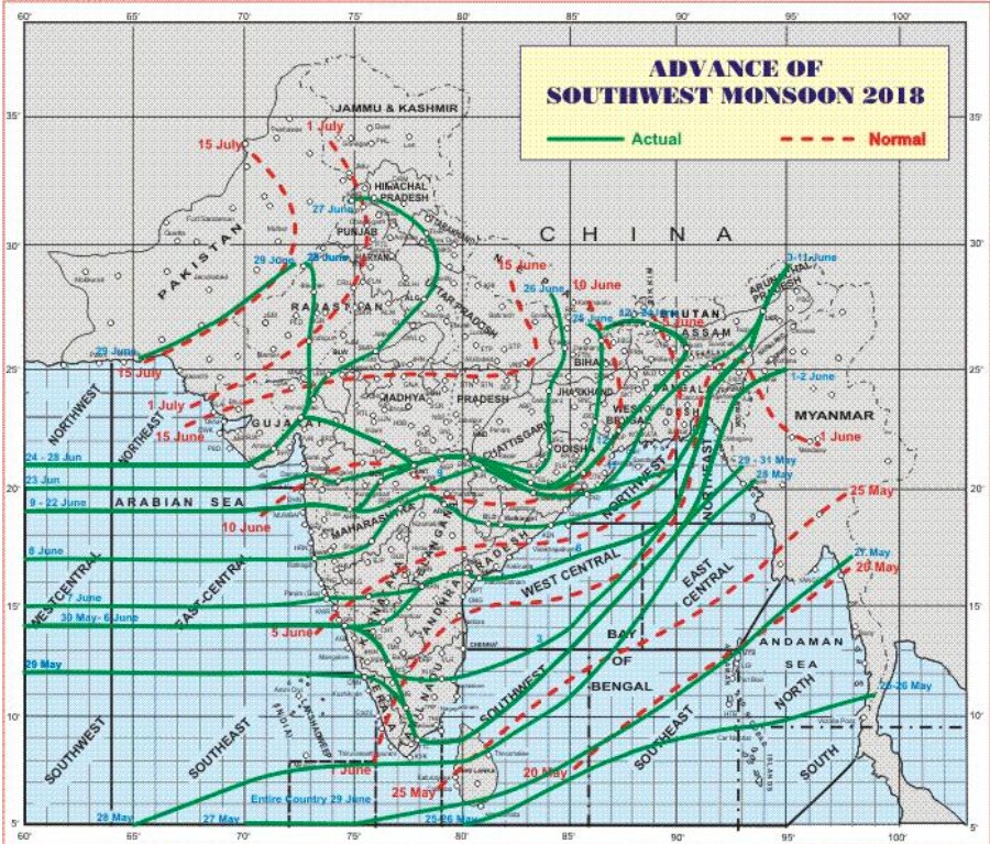
It begins from the middle of June to September. During this season,   the low-pressure condition over the northern plains intensifies which attracts the trade winds of the southern hemisphere. These south-east trade winds originate over the warm sub-tropical areas of the southern oceans. They cross the equator and blow in a south-westerly direction entering the Indian peninsula as the south-west monsoon. The inflow of the south-west monsoon into India brings about a total change in the weather which is related to the easterly jet stream that approaches the landmasses in two branches- The Arabian Sea Branch; The Bay of Bengal.

• The Arabian Sea branch cause more rainfall on the Western coast of India, the Western Ghats, Maharashtra, Gujarat and some areas of Madhya Pradesh. When it passes through Rajasthan hits the Himalayas and causes rainfall on the mountainous slopes of Jammu & Kashmir and Himachal Pradesh. Though this monsoon passes through Rajasthan but does not cause rainfall there due to two reason- Monsoon winds are parallel the Aravali Range; Dry and hot winds coming from Sindh region from Pakistan lessen the relative humidity of these monsoon winds and do not allow them to get saturated. Mawsynram in the southern ranges of the Khasi Hills receives the highest average rainfall in the world. Rainfall in the Ganga valley decreases from the east to the west.

• The Bay of Bengal branch enters India through West Bengal and reaches Haryana, Punjab and Rajasthan through Bihar and Uttar Pradesh.

The Autumn Season

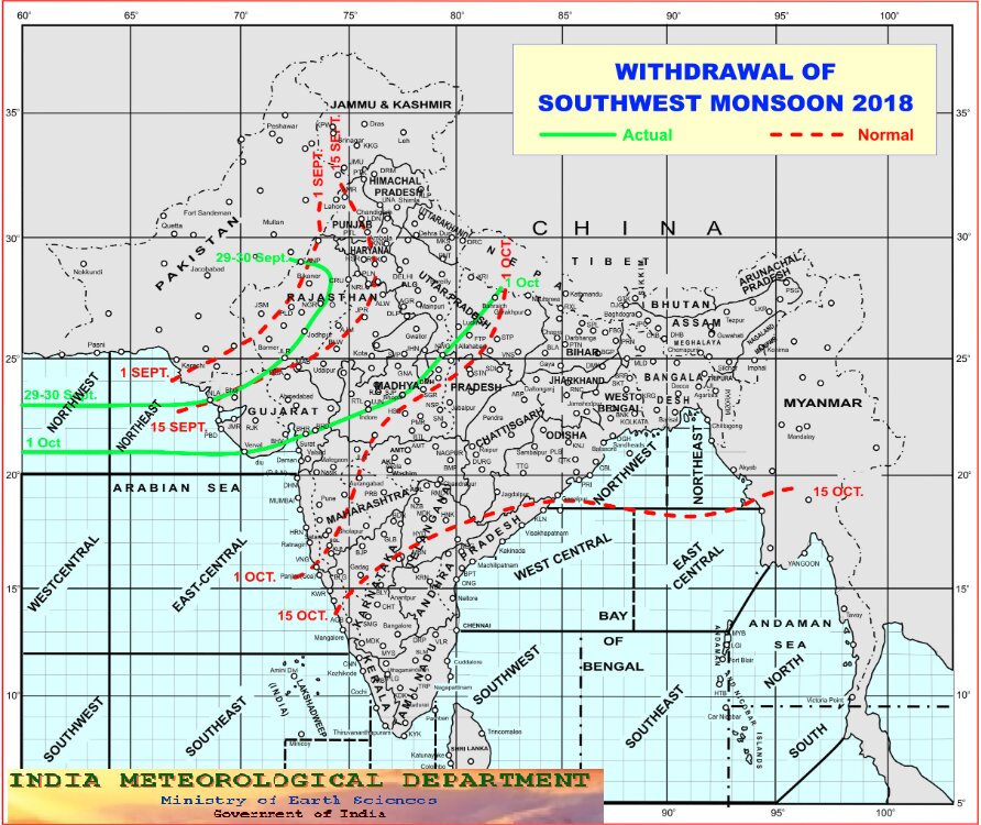
It begins after the rainy season from October to the middle of December. It is often called as the retreating season of monsoon which happened due to the gradual retreat of south-west monsoon. There is no rainfall in northern India but several cyclonic storms arise in the Bay of Bengal that moves from the north-east to the south-east along the eastern coast causing rainfall in the Tamil Nadu Coast and Sri Lanka.

Indian Climate


Previous                                                                                        Next

Indian Geography (Part-14)


Generally, across the world, the monsoons are experienced in the tropical area roughly between 20° N and 20° S.

The climate of India is described as the ‘monsoon’ type. In Asia, this type of climate is found mainly in the south and the southeast.

Out of a total of 4 seasonal divisions of India, monsoon occupies 2 divisions, namely.

1.  The southwest monsoon season - Rainfall received from the southwest monsoons is seasonal in character, which occurs between June and September.

2.  The retreating monsoon season - The months of October and November are known for retreating monsoons.

Factors Influencing South-West Monsoon Formation

1. The differential heating and cooling of land and water create a low pressure on the landmass of India while the seas around experience comparatively high pressure.

2. The shift of the position of Inter-Tropical Convergence Zone (ITCZ) in summer, over the Ganga plain (this is the equatorial trough normally positioned about 5°N of the equator. It is also known as the monsoon-trough during the monsoon season).

Inter-Tropical Convergence Zone

The Inter-Tropical Convergence Zone (ITCZ,) is a broad trough of low pressure in equatorial latitudes. This is where the northeast and the southeast trade winds converge. This convergence zone lies more or less parallel to the equator but moves north or south with the apparent movement of the sun.

3. The presence of the high-pressure area, east of Madagascar, approximately at 20°S over the Indian Ocean. The intensity and position of this high-pressure area affect the Indian Monsoon.

4. The Tibetan plateau gets intensely heated during summer, which results in strong vertical air currents and the formation of low pressure over the plateau at about 9 km above sea level.

5. The movement of the westerly jet stream to the north of the Himalayas and the presence of the tropical easterly jet stream over the Indian peninsula during summer.

6. Tropical Easterly Jet (African Easterly Jet).

7. Southern Oscillation (SO): Normally when the tropical eastern south Pacific Ocean experiences high pressure, the tropical eastern Indian Ocean experiences low pressure. But in certain years, there is a reversal in the pressure conditions and the eastern Pacific has lower pressure in comparison to the eastern Indian Ocean. This periodic change in pressure conditions is known as the SO.

El Nino

This is a name given to the periodic development of a warm ocean current along the coast of Peru as a temporary replacement of the cold Peruvian current. ‘El Nino’ is a Spanish word meaning ‘the child’, and refers to the baby Christ, as this current starts flowing during Christmas. The presence of the El Nino leads to an increase in sea-surface temperatures and weakening of the trade winds in the region.

Mechanism

The onset of the South-West Monsoon

1. The location of ITCZ shifts north and south of the equator with the apparent movement of the Sun.

2. During the month of June, the sun shines vertically over the Tropic of Cancer and the ITCZ shifts northwards.

3. The southeast trade winds of the southern hemisphere cross the equator and start blowing in southwest to northeast direction under the influence of Coriolis force.

4. These winds collect moisture as they travel over the warm Indian Ocean.

5. In the month of July, the ITCZ shifts to 20°-25° N latitude and is located in the Indo-Gangetic Plain and the south-west monsoons blow from the Arabian Sea and the Bay of Bengal. The ITCZ in this position is often called the Monsoon Trough.

6. The shift in the position of the ITCZ is also related to the phenomenon of the withdrawal of the westerly jet stream from its position over the north Indian plain, south of the Himalayas.

7. The easterly Jet Stream (Somali Jet) sets in along 15°N latitude only after the western jet stream has withdrawn itself from the region. This easterly jet stream is held responsible for the burst of the monsoon in India.

8. As these winds approach the land, their southwesterly direction is modified by the relief and thermal low pressure over northwest India. The monsoon approaches the Indian landmass in two branches:

The Arabian Sea branch - The monsoon winds originating over the Arabian Sea.

The Bay of Bengal branch - The Arakan Hills along the coast of Myanmar deflect a big portion of this branch towards the Indian subcontinent. The monsoon, therefore, enters West Bengal and Bangladesh from south and southeast instead of from the south-westerly direction.

Another phenomenon associated with the monsoon is its tendency to have ‘breaks’ in rainfall. The monsoon rains take place only for a few days at a time. They are interspersed with rainless intervals. These breaks in monsoon are related to the movement of the monsoon trough.

Despite an overall unity in the general pattern, there are perceptible regional variations in climatic conditions within the country.

Retreating Monsoon Season

1. The retreating southwest monsoon season is marked by clear skies and rise in temperature.

2. The land is still moist. Owing to the conditions of high temperature and humidity, the weather becomes rather oppressive. This is commonly known as the ‘October heat’.

3. In the second half of October, the mercury begins to fall rapidly, particularly in northern India.

4. The weather in the retreating monsoon is dry in north India but it is associated with rain in the eastern part of the Peninsula. Here, October and November are the rainiest months of the year.

5. The widespread rain in this season is associated with the passage of cyclonic depressions which originate over the Andaman Sea and manage to cross the eastern coast of the southern Peninsula. These tropical cyclones are very destructive.

6. A bulk of the rainfall of the Coromandel Coast is derived from these depressions and cyclones.

7. Unlike the rest of the country, which receives rain in the southwest monsoon season between June and September, the northeast monsoon is crucial for farming and water security in the south.

Impact of Monsoons on Life in India

Positive

1. About 64% of people in India depend on agriculture for their livelihood and agriculture itself is based on monsoon.

2. Agricultural prosperity of India depends very much on time and adequately distributed rainfall. If it fails, agriculture is adversely affected particularly in those regions where means of irrigation are not developed.

3. Regional variations in monsoon climate help in growing various types of crops.

4. Regional monsoon variation in India is reflected in the vast variety of food, clothes and house types.

5. Monsoon rain helps recharge dams and reservoirs, which is further used for the generation of hydro-electric power.

6. Winter rainfall by temperate cyclones in north India is highly beneficial for Rabi crops.

Negative

  • Variability of rainfall brings droughts or floods every year in some parts of the country.
  • Sudden monsoon burst creates a problem of soil erosion over large areas in India.
  • In hilly areas sudden rainfall brings landslide which damages natural and physical infrastructure subsequently disrupting human life economically as well as socially.

Monsoon Prediction In India

1. More than a century ago, when there were no computers, IMD’s forecasts depended only on snow cover. Lesser cover meant a better monsoon.

2. British physicist Gilbert Walker, who headed the IMD, designed a statistical weather model – an empirical way of predicting the weather – based on the relationship between two weather phenomena.

3. In 2014, the IMD started to use numerical models to supplement statistical models for long-range forecasting as well.

4. Now, although the numerical models used by the IMD are state-of-the-art – developed by the US National Centres for Environmental Prediction – their forecast capacity is still weak because a longer period of forecast creates more uncertainty in prediction.
5. At the moment, the IMD provides district-wise weather data but it’s not sufficient; because when IMD says there will be scattered rainfall over a particular district, it means that 26-50% that district (by area) will receive rainfall.
6. The IMD collects weather data like temperature, humidity, wind and precipitation through 679 automatic weather stations, 550 surface observatories, 43 radiosonde or weather balloons, 24 radars and three satellites.
7. Currently, highly advanced dynamical models need supercomputers. Prediction models will not run until proper data about current weather conditions is available.

Factors Responsible for Inaccurate Monsoon Forecast

1. The lack of data due to insufficient monitoring stations.

2. Automatic weather stations are of substandard quality. They need to be calibrated and cleaned regularly, which does not happen often. That affects data.

3. Then, there are major data gaps, like those involving dust, aerosols, soil moisture and maritime conditions are not monitored.

4. The models that we have brought from the west have been developed by western scientists to forecast in their region, little progress has been made is the fine-tuning of weather models to suit Indian conditions.

5. Lack of competent software professionals and scientists working with the IMD.

Recent Indian Initiatives

It is crucial for farmers (sowing, harvesting, etc.) and policymakers (payment of compensation, minimum support price, etc.) to know when and for how long the monsoon will remain active over India. For that, better predictions and timely advisories are needed.

To achieve this following initiatives have been taken:

Monsoon Mission of India

This initiative of Ministry of Earth Sciences, launched in 2012, has utilized new approaches (high resolution, super parameterizations, data assimilation etc.) so that forecast skill gets quantitatively improved further for forecasting services of India Meteorological Department (IMD).
For the first time, Indian Meteorological Department used the Monsoon Mission dynamical model to prepare operational seasonal forecast of 2017 monsoon rainfall over India.

Objectives
  1. To improve Seasonal and Intra-seasonal Monsoon Forecast
  2. To improve Medium-Range Forecast.
IMD in collaboration with Indian Council of Agricultural Research (ICAR) provides district-level agro-meteorological advisories to farmers through 130 agro-met field units in vernacular languages.
These advisories are used for critical farm operations such as:
  • Management of sowing (delayed onset of rains);
  • Changing crop variety (delay in rainfall);
  • Spraying Pesticides for disease control (occurrence of rainfall);
  • Managing Irrigation (Heavy rainfall Forecast).
India Meteorological Department (IMD) provides meteorological support to the Central Water Commission (CWC) for issuing flood warnings.

1. Indo-US expedition
In 2018, The Indian Ocean Research Vessel, 'Sagar Nidhi', set out from Chennai, as part of an Indo-US expedition seeking to find answers to the vagaries of the Bay of Bengal-fed southwest monsoon by collecting various data to improve prediction models.

2.National Supercomputing Mission will fill the necessary gaps in the computing superpower required to predict timely and accurate monsoon forecasts.

Global Warming and Monsoon

1. A drastic change in the monsoon rainfall intensity, duration, frequency and spatial distribution can be attributed to the climate change. However, it is too soon to arrive at a conclusion.
If all this is in response to global warming then it can be permanent and might accelerate. If not then the monsoon system will revert to a more normal state.
2. More data and reanalysis is needed to get a clear picture of the complete separation of the global warming impact from natural climate variability (such as El Niño).

Way Forward

1. The population of India is increasing and to provide food security to the population, a large part of the monsoon water which is currently unutilized should be held at suitable locations for irrigation and power generation purposes.
2. India needs to invest more resources in better prediction of Monsoon forecast in order to achieve reliability and sustainability.
3. With a warming climate, more moisture will be held in the atmosphere, leading to heavier rainfall, consequently, inter-annual variability of the monsoon will increase in future. The country needs to prepare for this change.
4. Thus, to secure and bring sustainability to the climate pattern of India we need to take effective and timely steps not just at the domestic front (National Action Plan on Climate Change) but also at the international front (UN Framework Convention on Climate Change), as we live in a shared world with a shared future.

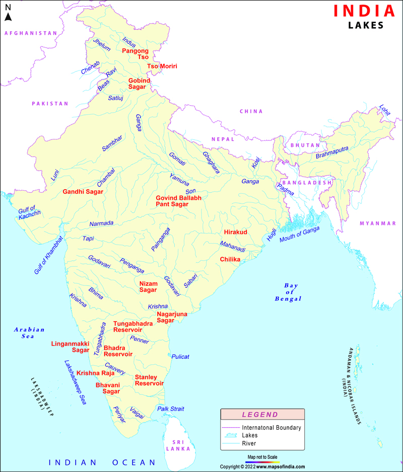
Major lakes of India || भारत की प्रमुख झील


Previous                                                                                        Next

Indian Geography (Part-13)


A lake is an area of variable size filled with water, localized in a basin, that is surrounded by land, apart from any river or other outlet that serves to feed or drain the lake.

Lakes lie on land and are not part of the ocean (except for sea lochs in Scotland and Ireland), and therefore are distinct from lagoons which are the shallow body of water separated from a larger body of water by barrier islands or reefs.

Lakes are also larger and deeper than ponds, though there are no official or scientific definitions. Lakes can be contrasted with rivers or streams, which are usually flowing. However, most lakes are fed and drained by rivers and streams.

Lakes can be broadly divided into two: –

(i) Natural Lakes

(ii) Artificial Lakes

Lakes whether they are natural or artificial are of great value to human beings.

(i) A lake helps to regulate the flow of a river.

(ii) It prevents flooding and promotes agriculture.

(iii) During the dry season, it helps to maintain an even flow of water and provides water for domestic proposes.

(iv) Lakes are used for developing Hydro-electric power.

(v) They influence the climate in the surrounding region.

(vi) Lakes maintain the aquatic ecosystem.

(vii) They enhance natural beauty and help develop tourism and provide recreation.

List of Famous/Major/Important Natural & Artificial Lakes in India


1. Kolleru Lake – Andhra Pradesh

  •  One of the largest freshwater lake in India.
  •  Located between Krishna and Godavari delta.
  •  Atapaka Bird Sanctuary is a located on the Kolleru Lake.

2. Sambhar Lake – Rajasthan

  •  India’s largest inland salt lake.
  •  It is a bowl shape lake encircles historical Sambhar Lake Town located 96 km south-west of the city of Jaipur (Northwest India) and 64 km northeast of Ajmer along National Highway 8 in Rajasthan.
  •  Mahabharata mentions the Sambhar lake as part of the kingdom of the demon king Brishparva.

3. Pushkar Lake – Rajasthan

  •  Located in the town of Pushkar in Ajmer district of the Rajasthan.
  •  Pushkar Lake is a sacred lake of the Hindus.

4. Wular Lake – Jammu Kashmir

  •  Largest Freshwater lake in India.
  •  Wular lake can spread over nearly 200-sq-km but its actual surface area tends to vary during the year.
  •  The Jhelum River flows into the lake, 40-km downstream from Srinagar, and then out again.
  •  Lake basin was formed as a result of tectonic activity and is fed by the Jhelum River.

5. Pulicat Lake- Andhra Pradesh

  •  Second largest brackish – water lake or lagoon in India.
  •  The large spindle-shaped barrier island named Sriharikota separates the lake from the Bay of Bengal.
  •  The island is home to the Satish Dhawan Space Centre, the launch site of India’s successful first lunar space mission, the Chandrayaan-1.

6. Loktak Lake -Manipur

  •  The largest freshwater lake in North -East India
  •  Keibul Lamjao the only floating national park in the world floats over it, which is the last natural refuge of the endangered sangai or Manipur brow-antlered deer.

7. Sasthamcotta Lake – Kerala

  •  The largest freshwater lake in Kerala.
  •  The purity of the lake water for drinking use is attributed to the presence of a large population of larva called cavaborus that consumes bacteria in the lake water.

8. Vembanad Lake -Kerala

  •  Vembanad (Vembanad Kayal or Vembanad Kol) is the longest lake in India, and the largest lake in the state of Kerala.
  •  It is known as Punnamada Lake in Kuttanad and Kochi Lake in Kochi.
  •  The Nehru Trophy Boat Race is conducted in a portion of the lake.

9. Chilka Lake -Odisha

  •  Chilika Lake is a brackish water lagoon, spread over the Puri, Khurda and Ganjam districts of Odisha state on the east coast of India, at the mouth of the Daya River, flowing into the Bay of Bengal, covering an area of over 1,100 km2.
  •  It is the largest coastal lagoon in India and the second largest lagoon in the world.
  •  Chilika Lake is the largest wintering ground for migratory birds, on the Indian sub-continent.

10. Dal Lake – Jammu Kashmir

  •  Dal Lake is a lake in Srinagar and is integral to tourism known as the “Jewel in the crown of Kashmir” or “Srinagar’s Jewel”.
  •  Asia’s largest Tulip garden is on the banks of Dal Lake.
  •  Mughal gardens, Shalimar Bagh and the Nishat Bagh are on the banks of Dal Lake.

11. Nalsarover Lake- Gujarat

  •  The Nalsarovar Lake in Gujarat is probably the largest water bird sanctuary in the country.
  •  The Nalsarovar Lake is mainly inhabited by migratory birds in winter and spring, it is the largest wetland bird sanctuary in Gujarat, and one of the largest in India.
  •    It was declared a bird sanctuary in April 1969.

12. Tsomgo Lake – Sikkim

  •  Tsongmo Lake or Changu Lake is a glacial lake in the East Sikkim.
  •  The lake is the venue for the Guru Purnima festival in which Jhakris of Sikkim assemble at the lake area to derive benefits from the healing qualities of the lake waters.

13. Bhimtal Lake – Uttarakhand

  •  Bhimtal Lake is a lake in the town of Bhimtal, in the Indian state of Uttarakhand, with a masonry dam built in 1883 creating the storage facility
  •  It is the largest lake in Kumaon region, known as the “lake district of India”.
  •  “C” shaped lake.

14. Barapani Lake- Meghalaya

  •  Barapani or Umiam Lake is in Shillong.
  •  The origin of Lake in 1965 is due to the Umiam Umtru Hydro Electric Power Project,the first Hydel power project in the North-east region of India.

15. Nainital Lake – Uttarakhand

  •  Nainital Lake, a natural freshwater body, situated amidst the township of Nainital in the Uttarakhand State of India
  •  Kidney shaped or crescent-shaped.

16. Periyar Lake -Kerala

  •  Periyar Lake is formed by the construction of the dam across the Mullaperiyar River in 1895.
  •  The notable elephant reserve and a tiger reserve, Periyar Wildlife Sanctuary is located on the banks of Periyar lake.

17. Hussain Sagar Lake – Telengana

  •  The lake is in Hyderabad, built by Hazrat Hussain Shah Wali in 1562, during the rule of Ibrahim Quli Qutub Shah.
  •  Connects the twin cities of Hyderabad and Secunderabad.
  •  A major attraction at the Hussain Sagar is the 16 meters high, 350 tonnes monolithic Buddha statue on the ‘Rock of Gibraltar’ installed at the centre of the lake.

18. Salim Ali Lake – Maharashtra

  •  It has been renamed after the great ornithologist, naturalist Salim Ali and also known as birdman of India.
  •  Salim Ali Sarovar (lake) popularly known as Salim Ali Talab is located near Delhi Gate, opposite Himayat Bagh, Aurangabad.

19. Kanwar Lake- Bihar

  •  Kanwar Lake Bird Sanctuary comprising water ponds, marshes and forests is a home for different species of wild animals, birds, plants etc.
  •  The Kanwar Taal or Kabar Taal Lake is Asia’s largest freshwater oxbow lake.

20. Nakki Lake – Rajasthan

  •  It is a very ancient sacred Lake, according to the Hindu legend. It is called by this name because it was dug out from Nails (Nakh).
  •  ‘Nakki Lake is situated in the Indian hill station of Mount Abu in Aravalli range.
  •  Mahatma Gandhi’s ashes were immersed in this Holy Lake on 12 February 1948 and Gandhi Ghat was constructed.

21. Bhojtal Lake- Madhya Pradesh

  • Also known as Upper Lake lies on the western side of the capital city of Madhya Pradesh, Bhopal.
  • It is a major source of drinking water for the residents of the city, serving around 40% of the residents with nearly 30 million imperial gallons (140,000 m3) of water per day.
  • Bada talaab, along with the nearby Chhota Talaab, meaning small lake in Hindi, constitute Bhoj Wetland, which is now a Ramsar site.
  • Largest artificial lake in Asia.

22. Surajkund- Haryana

23. Ulsoor lake- Bangalore, Karnataka

24. Sambhar lake- Rajasthan

25. Pichola lake- Udaipur,  Rajasthan

26. Pangong lake- Ladakh,  Jammu and Kashmir