Indian Geography (part-1) Part-2

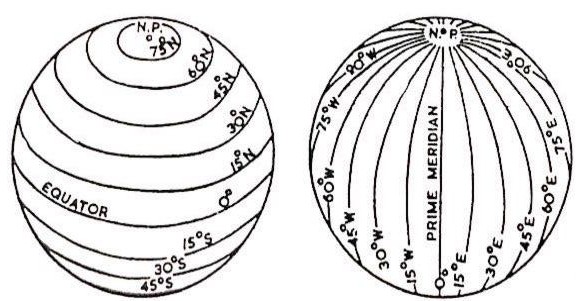
Latitude and longitude are a system of lines used to describe the location of any place on Earth. Lines of latitude run in an east-west direction across Earth. Lines of longitude run in a north-south direction. Although these are only imaginary lines, they appear on maps and globes as if they actually existed.

Latitude:-
Lines of latitude (also called parallels) circle Earth parallel to the Equator. The Equator is an imaginary line that lies halfway between the North Pole and the South Pole. It runs east-west all the way around Earth. Lines of latitude describe positions north and south of the Equator.
Lines of latitude are measured in degrees (°). Degrees may be broken down into smaller units called minutes (′) and seconds (″). The Equator is 0°. The North Pole is 90° north (N), and the South Pole is 90° south (S). Lines of latitude north of the Equator are numbered from 1° to 89° N. Lines of latitude south of the Equator are numbered from 1° to 89° S.

Longitudes:-
Lines of longitude run between the North Pole and the South Pole. These lines are also called meridians. Like lines of latitude, meridians are measured in degrees, minutes, and seconds.
The north-south line that marks 0° longitude passes through Greenwich, England. This is called the Greenwich, or prime, meridian. Greenwich was chosen for the prime meridian because when the system of latitude and longitude was established Great Britain was a world leader in exploration and map-making.
Concept Of Time Difference:-

The Earth rotates from west to East and takes 24 hours to rotate a full circle on its own axis, which causes day and night. As discussed above we all knew that the earth can be divided into 360 equal parts, which are called longitude. if we do a little bit of math here
360° in 24 hours
24 hours = 24×60 minutes =1440 minutes
Now
360° in 1440 min
So the earth will rotate 1° in 1440÷360= 4 minutes
we can clearly reach to a conclusion that the time taken by Earth to rotate 1 Degree on its axis is 4 minutes.
All-time zones are measured from a starting point centred at England's Greenwich Observatory. This point is known as the Greenwich Meridian or the Prime Meridian. Time at the Greenwich Meridian is known as Greenwich Mean Time (GMT) or Universal Time.
We just need to take the value of longitude at that place and multiply it by 4, after performing this little math we get the time difference that place has with respect to the Greenwich line.
We just need to take the value of longitude at that place and multiply it by 4, after performing this little math we get the time difference that place has with respect to the Greenwich line.
The geographical position of India:-

- The total area of India (Mainland + Islands) is 3287000 squares kilometres.
- India is situated in Northern hemisphere or specifically North Eastern hemisphere.
- India's latitude stretch is from 8°4' N to 37°6' N.
- Longitudinal stretch is from 68°7' E to 97°25' E.
NOTE:- The mainland of India starts from 8°4' N but the southernmost point of India is Indira Point in great Nicobar which is at 6°4' N.
- India is covering a total of 30 longitudes roughly from 68° E to 98° E.
So, Total time is taken to rotate these
30 longitudes will be 4 x 30= 120 minutes= 2 hours.
From here we can clearly see that there is a difference of 2 hours in time of the easternmost point of India(Kibithu in Arunachal Pradesh) and the westernmost point of India(Ghuar Moti, the Kutch District of Gujarat) in other words the sunrise in Eastern states occurs 2 hours before the Western States.
To solve this problem of time difference every country takes a reference point (generally at the middle of the longitude passing through the country) for their Standard Time.
- India has taken the Indian standard time with the reference to the 82°5' E longitude which passes from Naini Prayagraj.
- Indian Standard Time Longitude 82°5' E passes through a total of five states of India. These are as follows -
- Uttar Pradesh.
- Madhya Pradesh.
- Chhattisgarh.
- Odisha.
- Andhra Pradesh.
- Tropic of Cancer 23°5' N passes through 8 states of India. These are as follows -
- Gujarat.
- Rajasthan.
- Madhya Pradesh.
- Chhattisgarh.
- Jharkhand.
- West Bengal.
- Tripura.
- Mizoram.
NOTE:- Tropic of Cancer is longest in Madhya Pradesh.
- Ranchi(capital of Jharkhand) is situated on the line of cancer.
- Two more cities are closest to the line of Cancer are Gandhinagar (Gujarat), Bhopal (Madhya Pradesh).
- Land border of India is 15,106.7 km.
- Coastline length of the mainland is 6100 kilometre and coastline length with Islands is 7516 kilometre.
- The total length of the Indian border 22716 kilometres (approx.).
- There is a total of 9 states of India which have a coastline.
(Eastern Coast)
Tamil Nadu Andhra Pradesh Odisha West Bengal
(Eastern Coast)
Tamil Nadu Andhra Pradesh Odisha West Bengal
(Eastern Coast)
- States with the longest coastline (Descending)
- Gujarat.
- Andhra Pradesh.
- Tamilnadu.
- State* with the smallest coastline is Goa.
- UT* with the smallest coastline is Puducherry,
This is a basic introduction of Indian geography. If you have any query, please feel free to comment and ask.

Achha hai content kafi or kafi Aasan tarike se btaya gya h
ReplyDelete