Indian Geography (part-2)
Countries having Land boundaries with India:-
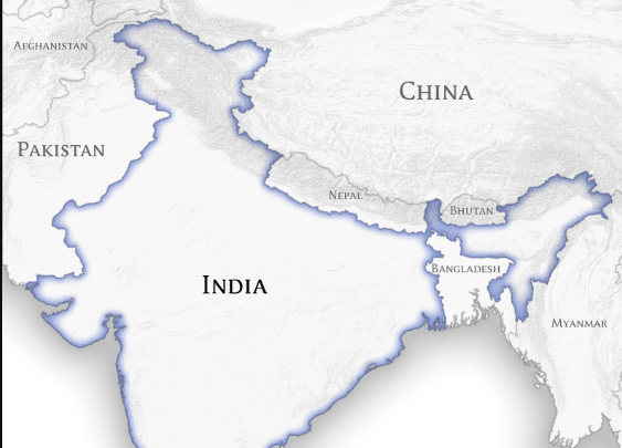
- India shares its border with seven countries-
- Pakistan.
- Afghanistan.
- China.
- Nepal.
- Bhutan.
- Myanmar.
- Bangladesh.
- States touching neighbouring countries:-
1. Pakistan
- Gujarat.
- Rajasthan.
- Punjab.
- Jammu and Kashmir( not a state anymore now a union territory).
- Jammu and Kashmir*.
3. China
- Jammu and Kashmir*.
- Himachal Pradesh.
- Uttarakhand Sikkim.
- Arunachal Pradesh.
- Bihar.
- Uttar Pradesh.
- Uttarakhand.
- West Bengal.
- Sikkim.
- West Bengal.
- Sikkim.
- Assam.
- Arunachal Pradesh.
- Arunachal Pradesh.
- Nagaland.
- Mizoram.
- Manipur.
- Assam.
- West Bengal.
- Meghalaya.
- Tripura.
Some important points:-
- Tripura is covered from three sides by Bangladesh.

- There are three Indian states that shares boundary with three countries:-
2. West Bengal {Nepal, Bhutan, Bangladesh}.
3. Sikkim {China, Nepal, Bhutan}.

Countries that do not share land boundaries with India but our neighbours
- Sri Lanka
- Maldives
Important terminologies to Remember
1. Durand line:- The Durand Line is an international 2,430-kilometre (1,510 mi) border between Afghanistan and Pakistan. It was originally established in 1893 as the international border between British India and Afghanistan.
2. McMahon line:- The McMahon Line is the demarcation line between the Tibetan region of China and the North-east region of India.

3. Radcliffe line:- The Radcliffe Line was the boundary demarcation line between the Indian and Pakistani portions of the Punjab and Bengal provinces of British India.
Misc. Fact:-
- Largest state according to the area (in descending order) are
1. Rajasthan.
2. Madhya Pradesh.
3. Maharashtra.
4.Uttar Pradesh.
- Smallest state / UT is Lakshadweep.
- The state which shares its boundary with the maximum number of States is Uttar Pradesh. It shares its boundary with 8 neighbour States. Those are-
2 Himachal Pradesh.
3. Haryana.
4. Rajasthan.
5. Madhya Pradesh.
6. Chhattisgarh.
7. Bihar.
8. Jharkhand.
- The largest district of India in terms of area is Kutch of Gujarat.
- The smallest district of India in terms of area is Mahe of Pondicherry.
This is a basic introduction of Indian geography. If you have any query, please feel free to comment and ask.


Helpful content...
ReplyDeletePlz create more.
Bhot hi easy way me btaya gya hai sb..
ReplyDelete